


![]()
Diktaean Cave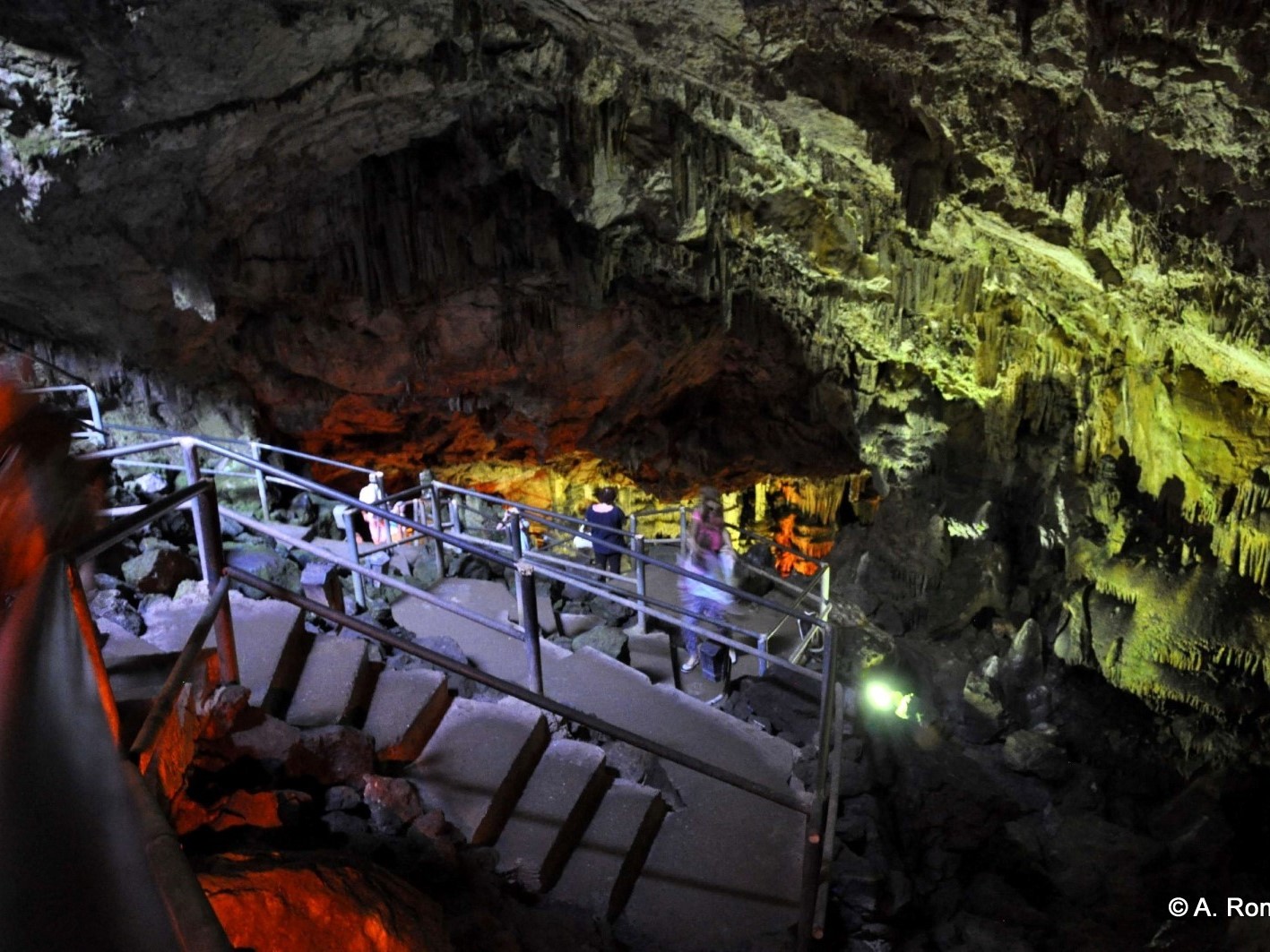
"Experience Quality and Affordability with Minotaurus Car Rentals for Your Journey to Dikteon Cave in Crete"Embark on a journey of discovery and adventure with our premium car rental services in Crete. At Minotaurus Car Rental Company, we understand the importance of quality and affordability when it comes to exploring the island's treasures, such as the renowned Dikteon Cave.Our fleet of well-maintained vehicles offers the perfect combination of reliability and comfort, ensuring a seamless travel experience for every customer. From compact cars to spacious SUVs, we have the perfect vehicle to suit your needs and budget.By choosing Minotaurus Car Rental Company , you not only gain access to top-quality vehicles but also benefit from competitive pricing that won't break the bank. We believe that everyone should have the opportunity to explore Crete's wonders without compromising on quality or budget.Whether you're planning a solo adventure or a family excursion to Dikteon Cave, trust Minotaurus Car Rental Company to provide you with the perfect vehicle for your journey. Book with us today and experience the ultimate blend of quality, affordability, and convenience on your Crete adventure.Unlock the wonders of Crete with Minotaurus Car Rental Company where quality meets affordability for your journey to Dikteon Cave and beyond.
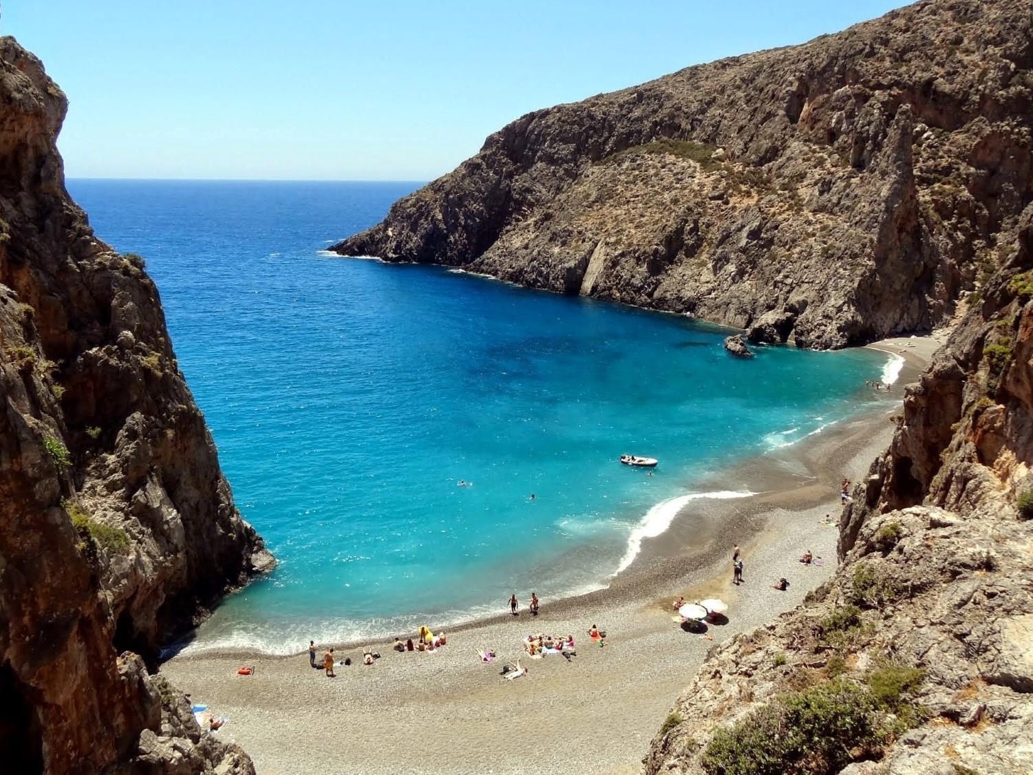
Preveli Palmbeach
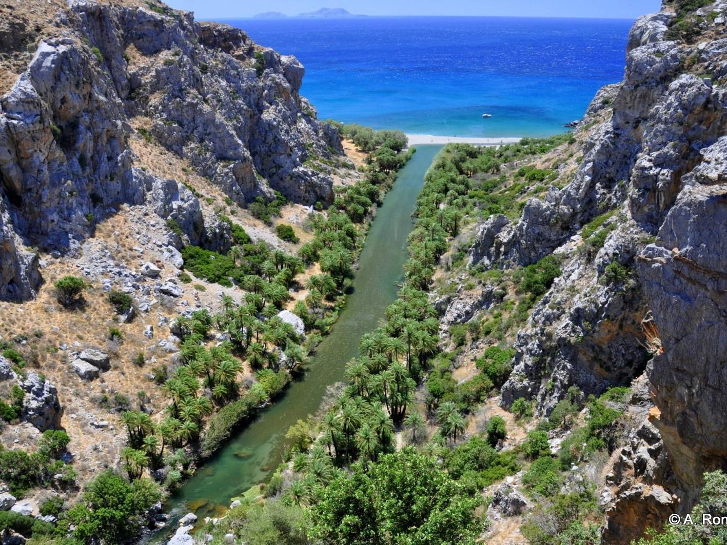
"Discover the Wonders of Preveli, Crete with Convenient Airport Car RentalsPlanning a trip to the enchanting village of Preveli in Crete? Make your journey hassle-free and memorable with our convenient airport car rental services at Heraklion Airport.At Minotaurus Car Rental Company we understand the importance of a smooth and stress-free travel experience. That's why we offer a wide range of high-quality vehicles to suit every traveler's needs and budget. From compact cars for solo adventurers to spacious SUVs for families, we have the perfect vehicle for your Preveli adventure.With our convenient airport location, picking up your rental car is quick and easy, allowing you to hit the road and start exploring Preveli's breathtaking landscapes, crystal-clear waters, and rich cultural heritage without delay.Experience the freedom to explore at your own pace, stopping to admire panoramic views, visit historical sites, and savor local delicacies along the way. Whether you're planning a day trip or an extended stay in Preveli, our reliable and affordable car rental services ensure that you make the most of your time in this stunning corner of Crete.Book your airport car rental with Minotaurus Car Rental Company today and embark on an unforgettable journey to Preveli, Crete. Let us be your trusted companion as you discover the beauty and charm of this hidden gem on the island."
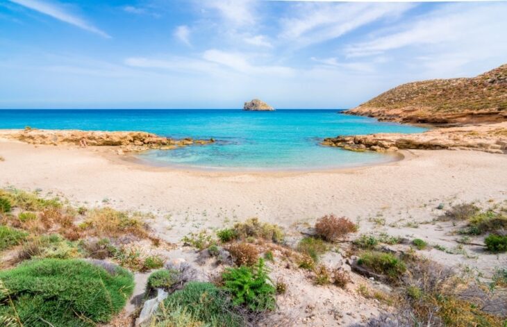
Elafonissi Beach
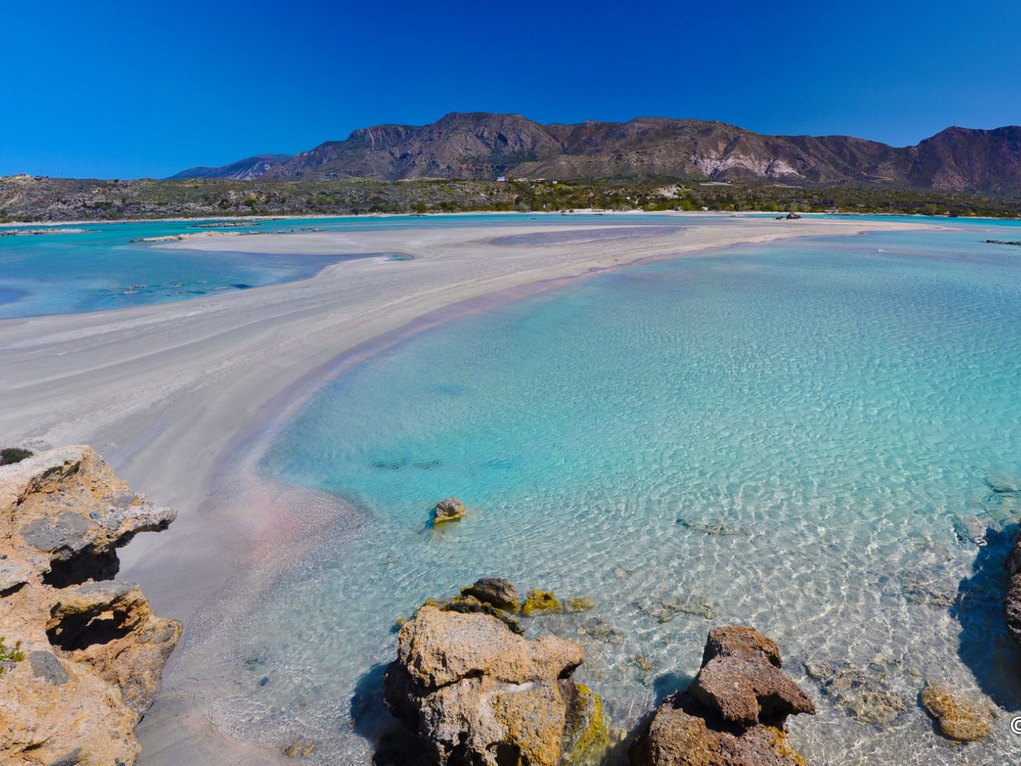
"Discover the Wonders of Preveli, Crete with Convenient Airport Car RentalsPlanning a trip to the enchanting village of Preveli in Crete? Make your journey hassle-free and memorable with our convenient airport car rental services at Heraklion Airport. We understand the importance of a smooth and stress-free travel experience. That's why we offer a wide range of high-quality vehicles to suit every traveler's needs and budget. From compact cars for solo adventurers to spacious SUVs for families, we have the perfect vehicle for your Preveli adventure.With our convenient airport location, picking up your rental car is quick and easy, allowing you to hit the road and start exploring Preveli's breathtaking landscapes, crystal-clear waters, and rich cultural heritage without delay.Experience the freedom to explore at your own pace, stopping to admire panoramic views, visit historical sites, and savor local delicacies along the way. Whether you're planning a day trip or an extended stay in Preveli, our reliable and affordable car rental services ensure that you make the most of your time in this stunning corner of Crete.Book your airport car rental with us today and embark on an unforgettable journey to Preveli, Crete. Let us be your trusted companion as you discover the beauty and charm of this hidden gem on the island."
Balos Lagoon
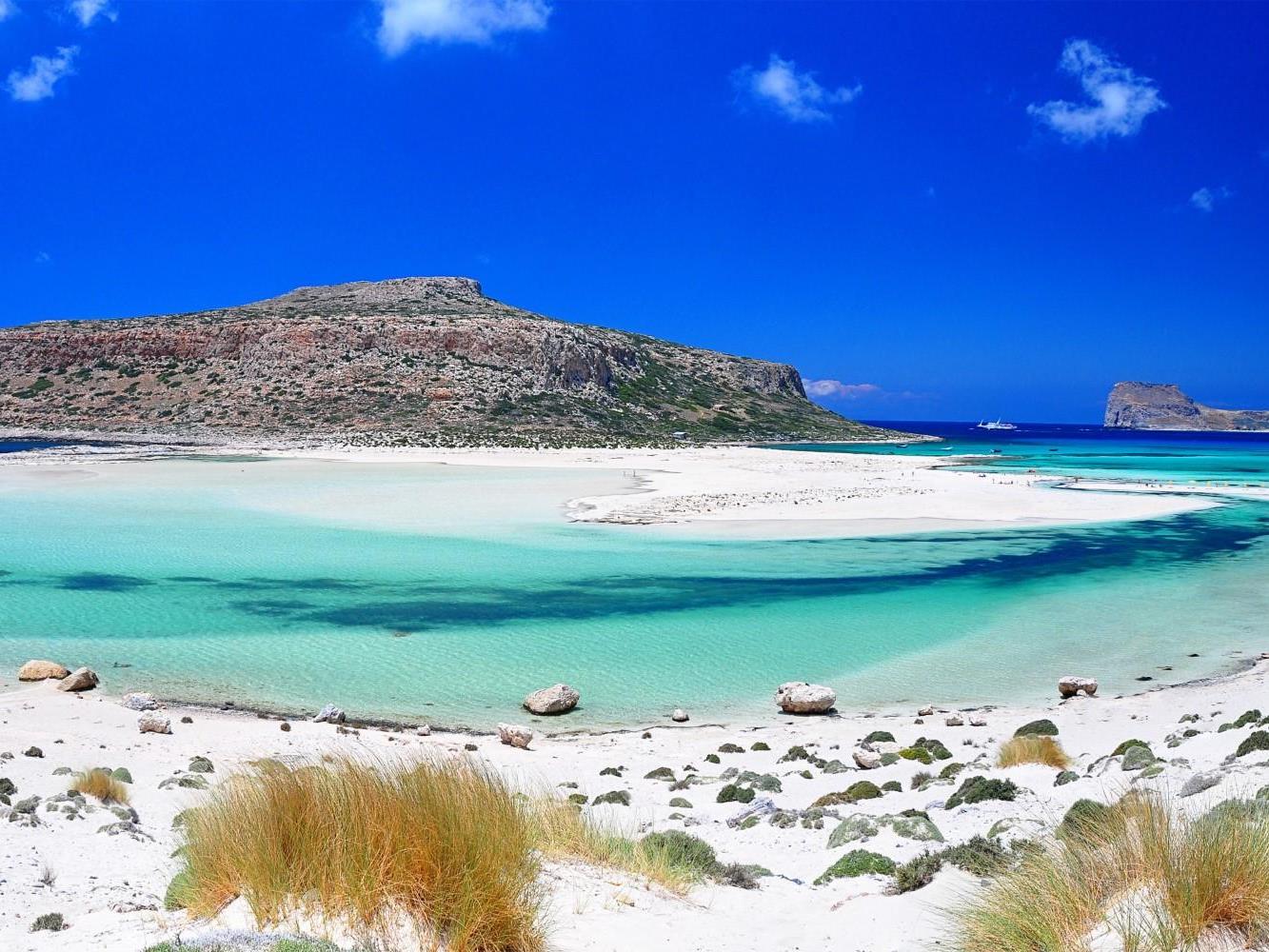
"Unleash Your Adventure: Explore Balos, Crete with Hassle-Free Car Rentals from Heraklion AirportReady to discover the hidden gem of Balos Beach in Crete? Make your journey unforgettable with our seamless car rental services available right at Heraklion Airport.We're dedicated to providing you with a stress-free travel experience from the moment you land. Our diverse fleet of vehicles caters to every type of traveler, ensuring you find the perfect ride for your Balos adventure. From compact cars for solo explorers to spacious vans for group outings, we've got you covered.With our convenient location at Heraklion Airport, picking up your rental car is a breeze, allowing you to hit the road and begin your journey to Balos without wasting a moment. Picture yourself cruising along the scenic coastal roads, with the crystal-clear waters of Balos awaiting your arrival.Experience the freedom to explore at your own pace, stopping to soak in panoramic views, take a dip in turquoise waters, and capture unforgettable memories along the way. Whether you're planning a day trip or an extended stay in Balos, our reliable and affordable car rental services ensure you have the flexibility to make the most of your time.Ready to turn your Balos dreams into reality? Book your airport car rental with Us today and embark on an adventure like no other. Let us be your trusted partner in creating memories that will last a lifetime."
Samaria Gorge
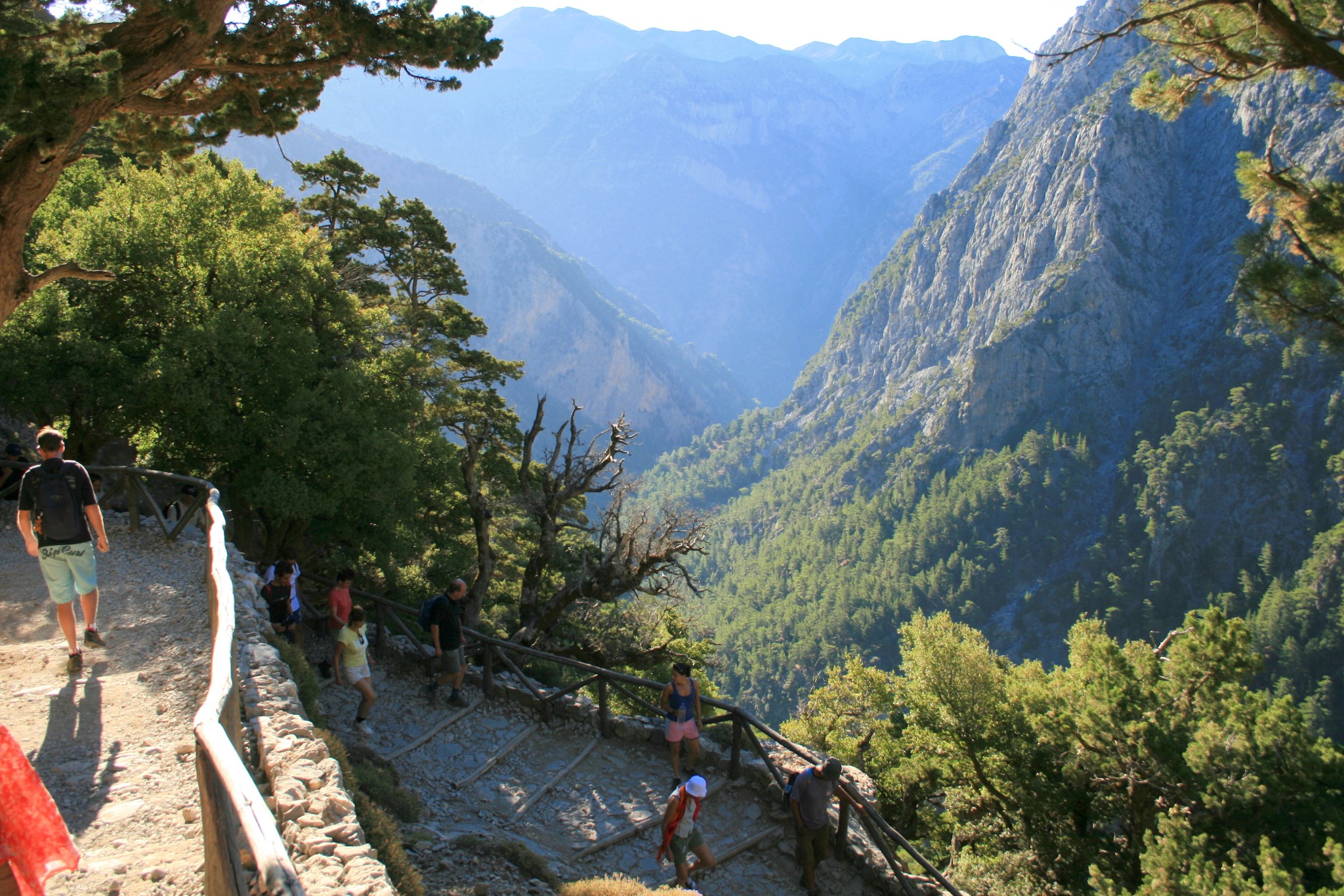
"Unlock Your Adventure: Explore Samaria Gorge with Affordable Car Rentals from Heraklion airport , Crete.Are you ready to embark on an unforgettable journey through the stunning Samaria Gorge in Crete? Look no further than our affordable car rental services based in Heraklion.At Minotaurus heraklion airport Car Rental Company we understand the allure of exploring the natural wonders of Samaria Gorge, and we're here to make your adventure seamless and hassle-free. With our fleet of well-maintained vehicles and budget-friendly prices, we're your ultimate partner in discovering the beauty of Crete's most iconic attraction. By choosing to rent from us, you gain the freedom to explore Samaria Gorge at your own pace, without the constraints of group tours or public transportation schedules. Picture yourself driving along the scenic routes of Crete, surrounded by rugged mountains and lush vegetation, as you make your way to the entrance of Samaria Gorge.Our commitment to providing quality service means you can trust us to provide a reliable and comfortable vehicle for your journey. Plus, with our competitive prices, you'll have more money left in your pocket to spend on memorable experiences along the way.Don't let transportation logistics hold you back from experiencing the breathtaking beauty of Samaria Gorge. Book your affordable car rental from Heraklion with Minotaurus Car Rental Company today, and get ready to embark on the adventure of a lifetime. Let us be your trusted companion as you explore one of Crete's most remarkable natural wonders."
Agiofarago Beach
"Discover the Wonders of Agiofaraggo, Crete: Rent a Reliable Car from Heraklion at Great PricesAre you ready to explore the breathtaking beauty of Agiofaraggo in Crete? Look no further than our reliable car rental services based in Heraklion, offering you the perfect blend of reliability and affordability.At [Your Car Rental Company], we understand the importance of both reliability and competitive pricing when it comes to planning your adventure. That's why we're committed to providing you with top-quality vehicles at prices that won't break the bank.When you choose to rent from us, you can trust that you'll be getting a reliable and well-maintained car that will safely take you to Agiofaraggo and back. Our vehicles undergo regular inspections and maintenance checks to ensure your peace of mind throughout your journey.But that's not all – we also offer some of the best prices in the market, ensuring that you get great value for your money. With our transparent pricing and no hidden fees, you can budget confidently and focus on making the most of your Agiofaraggo experience.Don't let transportation worries hold you back from experiencing the beauty of Agiofaraggo. Book your reliable and affordable car rental from Heraklion with Heraklion Car Rental Company] today, and get ready to embark on an unforgettable adventure. Trust us to be your reliable partner as you explore the wonders of Crete."
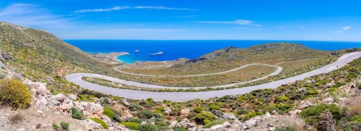
Richtis Gorge
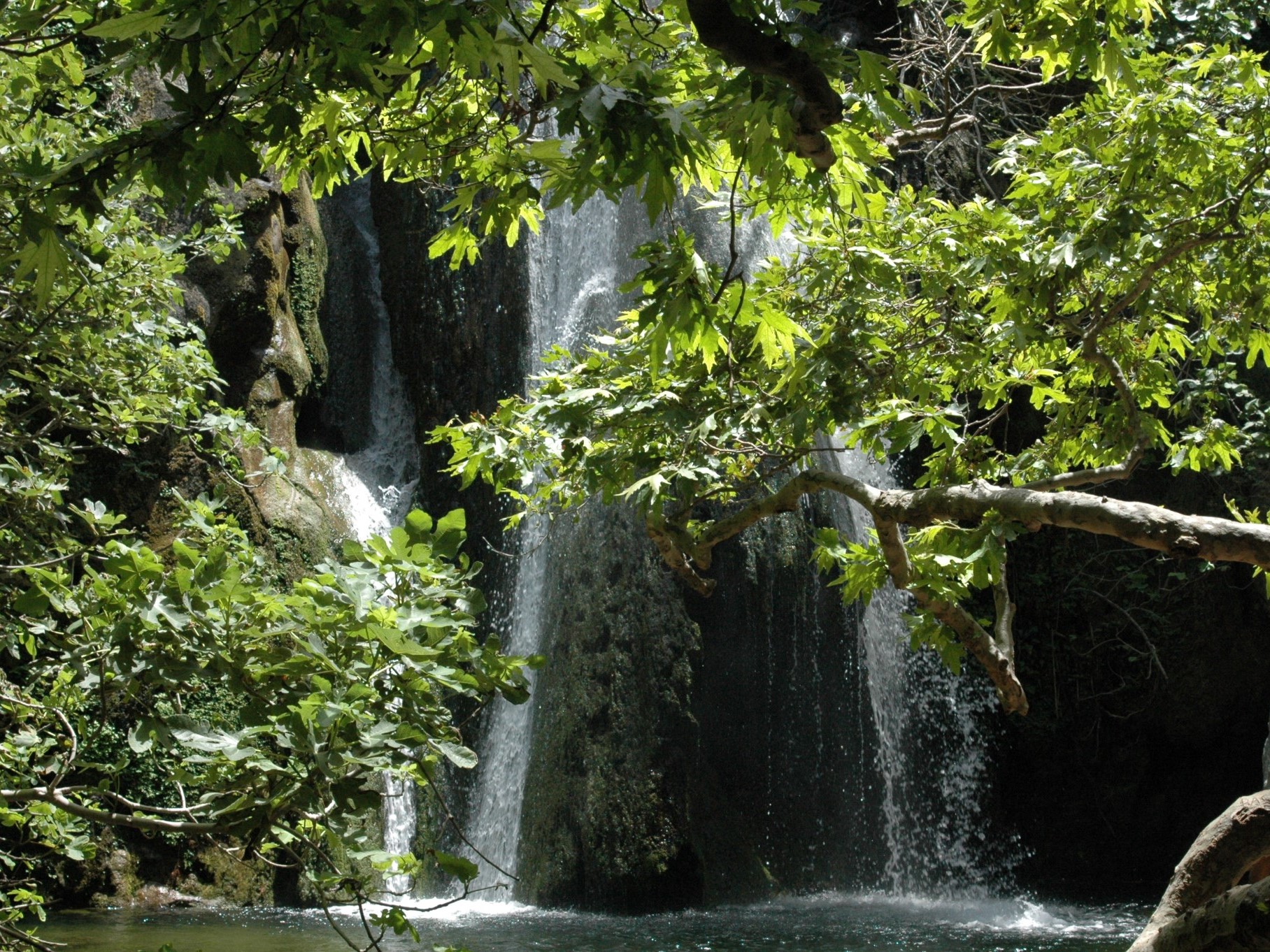
"The Richtis Gorge: Nature's Hidden Gem in Crete Tucked away in the rugged landscape of Crete lies the Richtis Gorge, a pristine natural wonder waiting to be discovered. Carved by the passage of time and the gentle flow of the Richtis River, this enchanting gorge offers a captivating journey through lush greenery, towering cliffs, and cascading waterfalls.As you venture into the heart of the Richtis Gorge, you'll be greeted by the soothing sounds of rushing water and the symphony of birdsong echoing through the canyon. Follow the meandering path as it winds its way alongside the crystal-clear river, offering glimpses of hidden caves, verdant vegetation, and dramatic rock formations along the way.One of the highlights of the Richtis Gorge is its magnificent waterfall, a breathtaking spectacle that cascades down from above, creating a refreshing oasis of tranquility amidst the rugged terrain. Take a moment to pause and marvel at the natural beauty surrounding you, or cool off with a refreshing dip in the crystal-clear waters of the pool below.Whether you're an avid hiker, a nature lover, or simply seeking a peaceful escape from the hustle and bustle of everyday life, the Richtis Gorge offers an unforgettable adventure in the heart of Crete's wilderness. Lace up your hiking boots, pack your camera, and prepare to immerse yourself in the untouched beauty of this hidden gem."
its Almost three hours from heraklion airport and for sure is one of the places someone has to rent a car and visit it
Tip: Most visitors leave their car in the central road at Exo Mouliana and walk down the paved road to meet the bridge Lahanas. You can gain around 30' minutes of walk if you drive and park next to the bridge of Lahanas; from there reaching the waterfall takes around 1.5-2 hours. However the lazy way to reach the warfall is to drive in the narrow paved road to the beach of Richtis and walk for around 30' in the opposite direction.
Minos Palace in Knossos
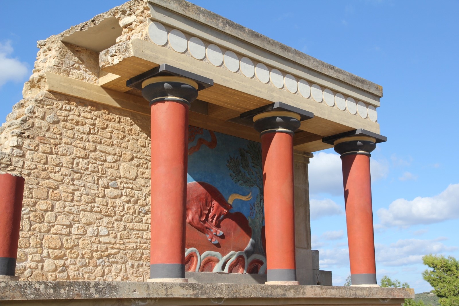
"Unravel the Mysteries of Knossos: Explore the Ancient Capital of Minoan CreteStep back in time and immerse yourself in the captivating history of Knossos, the ancient capital of Minoan Crete. As you wander through the ruins of this legendary archaeological site, you'll be transported to a bygone era, where grand palaces, intricate frescoes, and advanced engineering marvels once thrived.Discover the fascinating stories of the Minoan civilization, whose advanced culture and sophisticated society laid the foundation for Western civilization as we know it. Explore the labyrinthine corridors of the palace complex, marvel at the intricate craftsmanship of the restored frescoes, and imagine life in this bustling city over 4,000 years ago.As you explore Knossos, you'll uncover the secrets of its storied past – from its mythical connections to King Minos and the Minotaur to its role as a thriving trade hub in the ancient world. Whether you're a history enthusiast, an archaeology buff, or simply a curious traveler, Knossos offers a captivating journey through time unlike any other.Experience the magic of Knossos for yourself and witness the wonders of one of Europe's most significant archaeological sites. Book your trip to Crete today and embark on an unforgettable journey to the heart of Minoan civilization."
Rent your car from heraklion airport and visit one of the best myths on crete
"Perhaps the least popular but one of the most beautiful places in Crete."
"The Xerokampos Beach: Discovering the Hidden Gem of Sitia Tucked away on the eastern coast of Crete lies the pristine Xerokampos Beach, a hidden gem waiting to be discovered by adventurous travelers. With its crystal-clear turquoise waters, golden sandy beaches, and rugged cliffs, Xerokampos offers a slice of paradise away from the crowds.To embark on your journey to Xerokampos and explore its untouched beauty, renting a car from Heraklion Airport is the ideal option. With a rental car at your disposal, you'll have the flexibility to travel at your own pace and discover the hidden treasures of Crete's eastern coast.As you drive from Heraklion Airport towards Sitia, the scenic coastal route will take you through charming villages, olive groves, and vineyards, offering breathtaking views of the Aegean Sea along the way. Upon reaching Sitia, continue your journey towards Xerokampos, following the signs for this secluded paradise.Once you arrive in Xerokampos, you'll be greeted by a tranquil oasis of natural beauty, where you can unwind on pristine beaches, swim in crystal-clear waters, and soak up the sun amidst stunning surroundings. Explore the rugged coastline, discover hidden coves and sea caves, and marvel at the dramatic cliffs that frame the landscape.Whether you're a beach lover, a nature enthusiast, or simply seeking a peaceful escape, Xerokampos offers an unforgettable experience that will leave you feeling rejuvenated and inspired. So, rent a car from Heraklion Airport, set out on an adventure, and discover the hidden gem of Sitia and the breathtaking beauty of Xerokampos Beach."
Embark on a Spiritual Journey: Explore Crete's Religious Landmarks with a Rental Car from Heraklion AirportCrete, an island with a rich history and deep religious roots, offers a unique opportunity for travelers seeking spiritual enrichment. Some of the most intriguing landmarks of religious significance include ancient monasteries, monuments, and churches that reflect the complexity of faith and religion on the island.For travelers looking to explore these historic and religious landmarks, renting a car from Heraklion Airport is the ideal choice. Having your own means of transportation allows you to explore Crete at your own pace and discover every corner of the island with comfort and ease.From Heraklion Airport, you can start your spiritual journey by visiting landmarks such as the Arkadi Monastery, the Panagia Kera Monastery, and the Holy Trinity Monastery. Further exploration could lead you to unique places such as historic churches in Chania, ancient churches in Rethymno, and religious monuments in Heraklion.Additionally, you can venture to other notable sites such as the Cave of Zeus in Psychro, the Toplou Monastery in Sitia, and the Preveli Monastery overlooking the Libyan Sea.With the flexibility and independence that car rental provides, you can uncover every corner of Crete, from its warm beaches to its towering mountains and picturesque villages.By visiting these sacred places and landmarks, you will experience a unique journey of spiritual enrichment and cultural discovery. Explore the beauty and richness of Crete's religious culture with a rental car that will lead you on an unforgettable adventure."
10 Most Stunning Monasteries in Crete
Listed below are the most stunning monasteries in Crete:
- Preveli Monastery: Preveli Monastery, located in Crete, is an ancient monastery with a rich history dating back to the Venetian period. Comprising two complexes, it played a significant role in national endeavors for independence and education in Crete. Despite past challenges, it remains an influential institution and a popular tourist attraction, offering a glimpse into Rethymno’s history and culture.
- Arkadi Monastery: Arkadi Monastery, situated on a high plateau in Crete, is renowned for its pivotal role in the 1866 revolt. This historic site features strong fortifications and houses valuable icons. It serves as a symbol of resilience and is a popular destination for tourists interested in its rich history.
- Toplou Monastery: Toplou Monastery, also known as Moni Toplou, is a 15th-century monastery located in eastern Crete. Known for its defensive walls and historical significance, it has withstood the test of time. The monastery houses a museum showcasing its World War II history, making it a unique cultural and historical destination.
- Chrisoskalitissa Monastery: Chrisoskalitissa Monastery, perched atop a cliff in Chania, offers stunning sea views and a glimpse into the 17th century. Visitors can explore folklore and Byzantine museums, chapels, and a legendary “golden step.” This monastery provides a cultural and historical experience on the way to Elafonissi Beach.
- Agia Triada “Tzagaroli” Monastery: Agia Triada Monastery, located in Chania, was built in the 17th century and boasts Venetian architectural influence. Surrounded by fortified walls, it features a lush courtyard, chapels, a museum, and a library. This historical site allows visitors to explore its past and enjoy gourmet products.
- Gouverneto Monastery: Gouverneto Monastery, one of Crete’s oldest, was founded in 1537. It showcases fortress-like architecture and offers visitors the chance to explore chapels, including one dedicated to Saint John the Hermit. This historical site is open on select days, providing a unique experience in Crete’s history.
- Gonia Odigitria Monastery: Gonia Odigitria Monastery, near Kolymbari, stands on a high site with breathtaking views. Established in the 9th century and influenced by Venetian architecture, it features fortified walls, a beautiful courtyard, chapels, and a museum. A cannonball from past struggles remains a testament to its history.
- Prodromou Monastery “Korakies”: Prodromou Monastery of Korakies, near other renowned monasteries, is a traditional Easter gathering spot. Its history, though uncertain due to lost documents, survived destruction during the Greek revolt in 1821. Visitors can explore gardens, learn about historical crafts, and enjoy the peaceful surroundings, all for free.
- Vrontisi Monastery: Vrontisi Monastery, located in Crete, is a historical and cultural site with a rich past. Though specific details may vary, it offers visitors a chance to explore its architecture and history, contributing to Crete’s heritage.
- Katholiko Monastery: Katholiko Monastery, situated in Crete, is known for its secluded and tranquil setting. While historical details may be limited, its serene surroundings make it a peaceful destination for those seeking a quiet retreat.
- Moni Panagia Odigitria in Sivas: Panagia Odigitria Monastery, located in the Asterousia Mountains near Sivas in southern Crete, is one of the island’s oldest and most historic monasteries. With a fortress-like structure and a rich history, it offers visitors a glimpse into its past, including resistance against occupation.
- St George Monastery in Selinari: St George Monastery in Selinari, near Sissi town, is a testament to Cretan resilience. Dating back to the Second Byzantine period, it faced challenges but stands as a serene and historical site showcasing Byzantine icons and the island’s artistic heritage.
The Monastery of Preveli is a historic religious site located in southern Crete, Greece. Nestled amidst lush greenery and overlooking the Libyan Sea, it offers visitors a serene and spiritual retreat. Founded during the Middle Ages, the monastery has played a
significant role in the island's history and culture.To reach the Monastery of Preveli from Heraklion Airport, visitors can rent a car and embark on a scenic drive along the coastal roads of Crete. The journey takes approximately two and a half hours, offering stunning views of the
Cretan landscape along the way. Travelers can explore charming villages, olive groves, and picturesque beaches as they make their way towards this sacred destination.Upon arrival at the monastery, visitors are greeted by its imposing architecture and tranquil surroundings. They
can explore the various chapels, courtyards, and museums within the complex, learning about the monastery's rich heritage and spiritual significance. The monastery is also renowned for its stunning vistas, with panoramic views of the surrounding countryside and the azure
waters of the Libyan Sea.For those seeking a deeper spiritual experience, the Monastery of Preveli offers opportunities for prayer, meditation, and reflection. Visitors can attend religious services, participate in guided tours, or simply soak in the peaceful atmosphere of this sacred
sanctuary.A visit to the Monastery of Preveli is a journey of both cultural discovery and spiritual renewal. With its remote location and timeless beauty, it is a place where travelers can reconnect with nature, history, and their own inner selves. Renting a car from Heraklion Airport
provides the freedom and flexibility to explore this hidden gem at your own pace, creating memories that will last a lifetime.
The Arkadi Monastery is an iconic religious landmark located in the Rethymno region of Crete, Greece. Steeped in history and renowned for its architectural beauty, it stands as a symbol of Cretan resilience and independence.To journey to the Arkadi Monastery from Heraklion
Airport, travelers can opt to rent a car for a convenient and scenic drive through the heart of Crete. The route takes approximately one and a half hours, offering travelers the opportunity to explore the island's diverse landscape along the way.As visitors approach the monastery,
they are greeted by its impressive Venetian-style architecture and fortified walls, which date back to the 16th century. The monastery's picturesque surroundings, with olive groves and vineyards stretching as far as the eye can see, create a serene and contemplative
atmosphere.Upon arrival, visitors can explore the monastery's historic church, chapels, and courtyards, adorned with stunning frescoes and religious artifacts. They can also visit the monastery's museum, which houses a rich collection of manuscripts, icons, and relics, offering
insights into the region's cultural and religious heritage.One of the most significant aspects of the Arkadi Monastery is its role in Cretan history, particularly during the Cretan Revolt of 1866. The monastery became a symbol of resistance against Ottoman rule, as its monks and
civilians bravely defended it against a siege by Ottoman forces.Today, the Arkadi Monastery stands as a testament to the spirit of freedom and sacrifice, attracting visitors from around the world who come to pay their respects and learn about its storied past. Renting a car from
Heraklion Airport provides travelers with the flexibility to explore this historic site and its surrounding countryside at their own pace, ensuring a memorable and enriching experience in Crete.
The Toplou Monastery, also known as the Monastery of Panagia Akrotiriani, is a historic monastery located near the town of Sitia in eastern Crete, Greece. Perched on a hill overlooking the Libyan Sea, it is renowned for its striking architecture, rich history, and spiritual significance.To reach the Toplou Monastery from Heraklion Airport, travelers can rent a car for a scenic drive through the picturesque landscapes of eastern Crete. The journey takes approximately three hours, offering travelers the opportunity to explore charming villages, olive groves, and vineyards along the way.As visitors approach the monastery, they are greeted by its impressive Venetian-style architecture, with its fortified walls and imposing bell tower. The monastery's main church, dedicated to the Virgin Mary, features beautiful frescoes and religious icons that offer insight into the region's cultural and artistic heritage.One of the highlights of a visit to the Toplou Monastery is its museum, which houses a remarkable collection of religious artifacts, manuscripts, and Byzantine icons. Visitors can also explore the monastery's olive groves and vineyards, where they can sample local products such as olive oil and wine.The Toplou Monastery holds a special place in Cretan history, having played a significant role in the island's cultural and religious life for centuries. Today, it continues to attract visitors from around the world who come to admire its beauty, learn about its history, and experience its peaceful and spiritual atmosphere.Renting a car from Heraklion Airport provides travelers with the flexibility to explore the Toplou Monastery and its surrounding area at their own pace, ensuring a memorable and enriching experience in eastern Crete.
The Monastery of Chrysoskalitissa, also known as the Monastery of Panagia Chrysoskalitissa, is a historic religious site located on the southwestern coast of Crete, Greece. Perched atop a rocky promontory overlooking the Libyan Sea, it is renowned for its breathtaking views, rich history, and spiritual significance.To reach the Monastery of Chrysoskalitissa from Heraklion Airport, travelers can rent a car for a scenic drive along the coastal roads of western Crete. The journey takes approximately three hours, offering travelers the opportunity to soak in the stunning vistas of the Cretan landscape along the way.As visitors approach the monastery, they are greeted by its striking whitewashed walls and red-tiled roofs, which stand in stark contrast to the rugged coastline below. The monastery's main church, dedicated to the Virgin Mary, features beautiful frescoes and religious icons that reflect the island's Byzantine heritage.One of the highlights of a visit to the Monastery of Chrysoskalitissa is its dramatic setting, perched atop a sheer cliff overlooking the azure waters of the Libyan Sea. Legend has it that the monastery's name, which translates to "Golden Staircase," refers to a single golden step that is said to grant forgiveness to those who climb it on their knees.Today, the Monastery of Chrysoskalitissa continues to attract visitors from around the world who come to admire its beauty, learn about its history, and experience its peaceful and spiritual atmosphere. Renting a car from Heraklion Airport provides travelers with the flexibility to explore this hidden gem of Crete at their own pace, ensuring a memorable and enriching experience on the island.
The Monastery of Agia Triada Jagarolon, also known as the Monastery of Holy Trinity, is a historic religious complex located on the Akrotiri Peninsula, near Chania, Crete. Nestled amidst olive groves and vineyards, it is renowned for its stunning architecture, serene atmosphere, and cultural significance.To reach the Monastery of Agia Triada Jagarolon from Heraklion Airport, travelers can rent a car for a scenic drive through the picturesque landscapes of western Crete. The journey takes approximately two and a half hours, offering travelers the opportunity to explore charming villages, rolling hills, and scenic coastal vistas along the way.As visitors approach the monastery, they are greeted by its impressive Venetian-style architecture, with its red-tiled roofs and elegant arches. The monastery's main church, dedicated to the Holy Trinity, features beautiful frescoes and intricate woodcarvings that reflect the island's rich artistic heritage.One of the highlights of a visit to the Monastery of Agia Triada Jagarolon is its peaceful and tranquil surroundings, which provide a perfect setting for quiet contemplation and spiritual reflection. Visitors can explore the monastery's grounds, including its gardens, courtyards, and olive groves, while taking in panoramic views of the surrounding countryside and the shimmering waters of the Cretan Sea.Today, the Monastery of Agia Triada Jagarolon continues to serve as a place of worship and pilgrimage, attracting visitors from around the world who come to admire its beauty, learn about its history, and experience its timeless spirituality. Renting a car from Heraklion Airport provides travelers with the flexibility to explore this sacred sanctuary and its surrounding area at their own pace, ensuring a memorable and enriching experience on the island of Crete.
Upon arrival at the Monastery of Agia Triada Jagarolon, visitors are welcomed by the peaceful atmosphere and the scent of blooming flowers that fill the air. They can wander through the monastery's well-preserved buildings, admiring the intricate details of the architecture and soaking in the serenity of the surroundings.Inside the monastery, visitors can explore the various chapels, courtyards, and prayer rooms, each offering a glimpse into the monastery's rich history and spiritual significance. They can also visit the monastery's museum, which houses a remarkable collection of religious artifacts, manuscripts, and icons, providing insight into the island's cultural and religious heritage.For those seeking a deeper spiritual experience, the Monastery of Agia Triada Jagarolon offers opportunities for prayer, meditation, and contemplation. Visitors can attend religious services, participate in guided tours, or simply sit in quiet reflection amidst the tranquil beauty of the monastery grounds.After exploring the monastery, visitors can take a leisurely stroll through the surrounding olive groves and vineyards, or enjoy a picnic overlooking the breathtaking vistas of the Cretan countryside. With its idyllic setting and timeless beauty, the Monastery of Agia Triada Jagarolon offers a peaceful retreat from the hustle and bustle of modern life, allowing visitors to reconnect with nature, history, and their own inner selves.Renting a car from Heraklion Airport provides travelers with the freedom to explore the Monastery of Agia Triada Jagarolon and its surrounding area at their own pace, ensuring a memorable and enriching experience on the island of Crete. Whether seeking spiritual enlightenment, cultural enrichment, or simply a moment of tranquility, a visit to this historic monastery is sure to leave a lasting impression on all who journey here.
The Monastery of Gouverneto, also known as the Monastery of Our Lady of the Angels, is a historic religious site nestled in the rugged mountains of the Akrotiri Peninsula, near Chania, Crete. Surrounded by pristine natural beauty and steep cliffs, it is renowned for its serene atmosphere, stunning architecture, and spiritual significance.To reach the Monastery of Gouverneto from Heraklion Airport, travelers can rent a car for a scenic drive through the picturesque landscapes of western Crete. The journey takes approximately two and a half hours, offering travelers the opportunity to marvel at the breathtaking vistas of the Cretan countryside along the way.As visitors approach the monastery, they are greeted by its majestic presence, with its Byzantine-style architecture and imposing stone walls. The monastery's main church, dedicated to the Virgin Mary, features beautiful frescoes and religious icons that reflect the island's rich cultural heritage.One of the highlights of a visit to the Monastery of Gouverneto is its tranquil setting, surrounded by lush vegetation and towering cliffs. Visitors can explore the monastery's grounds, including its courtyards, gardens, and ancient chapels, while taking in panoramic views of the surrounding mountains and the shimmering waters of the Mediterranean Sea.Today, the Monastery of Gouverneto continues to serve as a place of worship and pilgrimage, attracting visitors from around the world who come to admire its beauty, learn about its history, and experience its spiritual significance. Renting a car from Heraklion Airport provides travelers with the flexibility to explore this hidden gem of Crete at their own pace, ensuring a memorable and enriching experience on the island.
Upon arrival at the Monastery of Gouverneto, visitors are enveloped in a sense of tranquility and reverence. They can explore the monastery's interior, admiring the intricate frescoes, ornate woodcarvings, and sacred relics that adorn its walls. The peaceful atmosphere invites contemplation and reflection, offering a respite from the stresses of everyday life.Outside the monastery walls, visitors can follow the path that leads to the nearby Cave of Arkoudiotissa, also known as the Bear Cave, where according to legend, a bear once guarded the hidden icon of the Virgin Mary. The cave is a site of pilgrimage for many, who come to pay their respects and seek blessings.For those seeking further adventure, the area surrounding the Monastery of Gouverneto offers numerous hiking trails that wind through rugged terrain, past hidden caves, and along scenic cliffs. Nature enthusiasts will delight in the opportunity to explore the diverse flora and fauna of the region, while history buffs can discover ancient ruins and archaeological sites scattered throughout the landscape.After a day of exploration, visitors can relax and unwind in the tranquil surroundings of the monastery, enjoying a picnic amidst the olive groves or simply soaking in the beauty of the natural surroundings. As the sun sets over the horizon, casting a golden glow over the mountains, visitors can reflect on the timeless beauty and spiritual significance of this sacred sanctuary.Renting a car from Heraklion Airport provides travelers with the freedom to embark on their own journey of discovery, exploring the Monastery of Gouverneto and its surrounding area at their own pace. Whether seeking solace, adventure, or simply a moment of quiet contemplation, a visit to this historic monastery is sure to leave a lasting impression on all who venture here.
The Monastery of Gonia Odigitria, situated on the southern coast of Crete, is a hidden gem steeped in history and spiritual significance. Nestled amidst the rugged landscape, this Byzantine monastery has been a beacon of faith for centuries, drawing pilgrims and travelers alike to its tranquil grounds.To reach the Monastery of Gonia Odigitria from Heraklion Airport, travelers can embark on a scenic journey along the coastal roads of southern Crete. Renting a car provides the flexibility to explore the island at one's own pace, allowing visitors to take in the breathtaking views of the Mediterranean Sea and the majestic mountains that line the horizon.Upon arrival at the monastery, visitors are greeted by the sight of its ancient stone walls and red-tiled roofs, set against a backdrop of olive groves and vineyards. Stepping inside, they are transported back in time, as they wander through the monastery's courtyard, chapels, and living quarters, each echoing with the whispers of centuries past.Inside the main church, visitors can marvel at the stunning frescoes and religious icons that adorn the walls, depicting scenes from the life of Christ and the saints. The peaceful atmosphere invites quiet contemplation and reflection, offering a respite from the hustle and bustle of modern life.After exploring the monastery, visitors can take a leisurely stroll through the surrounding countryside, breathing in the scent of wildflowers and listening to the gentle rustle of olive branches in the breeze. With its timeless beauty and spiritual aura, the Monastery of Gonia Odigitria offers a truly unforgettable experience for those who journey to its hallowed grounds.
The Monastery of Agios Prodromos, commonly known as the Monastery of Preveli, is a historic and revered religious site nestled in the rugged landscape of southern Crete. Perched on a cliff overlooking the Libyan Sea, this Byzantine monastery has long been a sanctuary for monks and pilgrims seeking spiritual solace.To reach the Monastery of Agios Prodromos from Heraklion Airport, travelers can embark on a picturesque journey along the southern coast of Crete. Renting a car provides the freedom to explore the island's stunning scenery, from olive groves and vineyards to rocky cliffs and turquoise waters.As visitors approach the monastery, they are greeted by the sight of its iconic stone walls and red-tiled roofs, set against the backdrop of the Cretan countryside. Stepping inside, they are enveloped in a sense of serenity and reverence, as they explore the monastery's courtyards, chapels, and living quarters.The main church, dedicated to St. John the Baptist, features exquisite frescoes and religious icons that tell the story of the monastery's rich history. Visitors can attend religious services and participate in the daily rituals of the monks, gaining insight into the spiritual life of this sacred community.After exploring the monastery, visitors can take a leisurely stroll through the surrounding olive groves and gardens, breathing in the scent of wild herbs and flowers. The monastery's cliffside location offers breathtaking views of the Libyan Sea and the rugged coastline below, providing a perfect backdrop for quiet contemplation and reflection.A visit to the Monastery of Agios Prodromos is a journey back in time, to a place where faith and tradition are deeply intertwined with the natural beauty of the Cretan landscape. Renting a car from Heraklion Airport allows travelers to embark on their own pilgrimage to this sacred sanctuary, ensuring a memorable and meaningful experience on the island of Crete.
The Monastery of Vrontisi, a hidden gem nestled in the heart of Crete, beckons travelers seeking solace and spiritual enlightenment. Situated amidst olive groves and vineyards, this ancient monastery exudes an aura of tranquility and serenity, offering a refuge from the hustle and bustle of modern life.To embark on a journey to the Monastery of Vrontisi from Heraklion Airport, travelers can opt to rent a car, providing them with the freedom to explore the island's picturesque landscapes at their own pace. The scenic drive takes visitors through winding mountain roads and quaint villages, offering glimpses of traditional Cretan life along the way.As travelers approach the monastery, they are greeted by the sight of its Byzantine-style architecture, characterized by its red-tiled roofs and whitewashed walls. Stepping through the entrance gate, they are transported back in time, as they wander through the monastery's courtyards and chapels, each steeped in history and tradition.Inside the main church, visitors can marvel at the stunning frescoes and religious icons that adorn the walls, depicting scenes from the life of Christ and the saints. The peaceful atmosphere invites quiet contemplation and reflection, providing a welcome respite from the stresses of everyday life.After exploring the monastery, visitors can take a leisurely stroll through the surrounding olive groves, breathing in the scent of wild herbs and flowers. With its timeless beauty and spiritual aura, the Monastery of Vrontisi offers a truly unforgettable experience for those who journey to its hallowed grounds.
The Catholic Monastery of Katochiko stands as a beacon of faith and history on the island of Crete. Nestled amidst the rugged terrain, this ancient monastery boasts a rich and storied past that dates back centuries.To embark on a journey to the Catholic Monastery of Katochiko from Heraklion Airport, travelers can opt to rent a car, allowing them the freedom to explore the island's diverse landscapes along the way. The scenic drive takes visitors through winding mountain roads and picturesque villages, offering glimpses of traditional Cretan life and breathtaking views of the Mediterranean Sea.As travelers approach the monastery, they are greeted by its imposing stone walls and Byzantine-style architecture, reminiscent of a bygone era. Stepping onto the monastery grounds, visitors are transported back in time, as they immerse themselves in the rich history and spiritual aura of this sacred site.The origins of the Catholic Monastery of Katochiko can be traced back to the Byzantine period, when it served as a center of religious worship and monastic life. Over the centuries, the monastery has weathered wars, invasions, and natural disasters, yet it has remained a symbol of resilience and faith for generations of believers.Inside the monastery, visitors can explore its ancient chapels, adorned with stunning frescoes and religious icons that tell the story of Christianity's enduring presence on the island. The tranquil courtyards and gardens provide a serene setting for contemplation and prayer, offering a welcome escape from the hustle and bustle of modern life.As visitors wander through the monastery's halls, they can learn about its fascinating history and the role it has played in shaping the spiritual landscape of Crete. From its humble beginnings to its present-day significance, the Catholic Monastery of Katochiko continues to inspire awe and reverence in all who visit its hallowed grounds.
Nestled amidst the rugged landscape of Crete, the Monastery of Panagia Odigitria stands as a testament to faith and heritage. This sacred site, also known as the Monastery of Our Lady of the Guide, holds a storied past dating back centuries.To embark on a journey to the Monastery of Panagia Odigitria from Heraklion Airport, travelers can opt to rent a car, granting them the freedom to explore the island's diverse terrain at their own pace. The scenic drive winds through picturesque villages and olive groves, offering panoramic views of the Cretan countryside along the way.As visitors approach the monastery, they are greeted by its imposing walls and traditional architecture, a sight that evokes a sense of reverence and wonder. Stepping onto the monastery grounds, one is enveloped in an atmosphere of tranquility and spirituality, as the echoes of centuries-old prayers seem to linger in the air.The history of the Monastery of Panagia Odigitria is deeply intertwined with the island's past, tracing its roots back to the Byzantine era. Over the centuries, it has served as a beacon of faith and a center of religious life for the local community.Inside the monastery, visitors can explore its ancient chapels and ornate frescoes, each telling a story of devotion and devotion to the Virgin Mary. The peaceful courtyards and lush gardens provide a serene backdrop for contemplation and reflection, inviting visitors to pause and connect with their spiritual selves.As travelers delve into the history of the Monastery of Panagia Odigitria, they gain insight into the rich tapestry of Cretan culture and tradition. From its humble beginnings to its present-day significance, this sacred site continues to inspire awe and reverence in all who seek its hallowed halls.
Nestled amidst the rugged landscapes of Crete, the Monastery of Saint George at Selinari stands as a beacon of spirituality and cultural heritage. Perched atop a rocky promontory overlooking the shimmering Aegean Sea, this ancient sanctuary has been a place of pilgrimage and devotion for centuries.To reach the Monastery of Saint George at Selinari from Heraklion Airport, travelers can opt to rent a car, providing them with the flexibility to explore the island's treasures at their own pace. The scenic journey takes adventurers along winding coastal roads and through quaint villages, offering glimpses of traditional Cretan life along the way.As visitors approach the monastery, they are greeted by its imposing walls and traditional architecture, a testament to the resilience of faith in the face of time. Stepping onto the monastery grounds, one is enveloped in a sense of serenity and tranquility, as the echoes of ancient prayers seem to resonate in the air.The history of the Monastery of Saint George at Selinari is steeped in legend and lore, with tales of miraculous interventions and divine protection. Founded in the 16th century, the monastery has served as a spiritual refuge for travelers and pilgrims seeking solace and guidance on their journey.Inside the monastery, visitors can explore its ancient chapels and revered relics, each offering a glimpse into the rich tapestry of Cretan spirituality. The peaceful courtyards and shaded gardens provide a serene setting for contemplation and reflection, inviting visitors to connect with their inner selves and the divine.As travelers delve into the history of the Monastery of Saint George at Selinari, they discover a deep sense of reverence and awe for this sacred site. From its humble beginnings to its enduring legacy, this ancient sanctuary continues to inspire all who seek its hallowed grounds.

Explore Local Cuisine: Crete's culinary scene is rich and diverse, offering a wide variety of traditional dishes made with fresh, locally sourced ingredients. With your rental car, you can venture into small villages and seaside towns to discover authentic tavernas and family-run restaurants serving up mouthwatering Cretan specialties. From succulent grilled meats and seafood to hearty stews and savory pies, there's something to please every palate. Embark on a Culinary Journey: Plan a culinary itinerary, visiting different restaurants and tavernas in various parts of the island. With your car, you can easily hop from one destination to another, sampling a diverse array of dishes along the way. Whether you're craving the flavors of the sea in coastal villages or the earthy goodness of mountainous tavernas, Crete offers a culinary adventure like no other. Immerse Yourself in Local Experience: Dining in Crete is more than just a meal—it's an opportunity to immerse yourself in the local way of life and culture. Use your car to explore traditional villages, participate in local festivals and events, and engage with friendly locals. By embracing the island's culinary traditions and hospitality, you'll create memories that will last a lifetime. Incorporate Food and Car Rental Packages: Some car rental companies offer packages that include discounts or vouchers for dining at select restaurants. Consider opting for one of these packages to enhance your culinary experience in Crete while also enjoying the convenience of having a rental car at your disposal. Overall, combining car rental with culinary exploration allows you to savor the flavors of Crete at your own pace, uncover hidden gastronomic gems, and create unforgettable memories of your journey through this enchanting island.
Explore Scenic Routes: Crete boasts stunning landscapes, from rugged mountains to pristine beaches and fertile valleys. With your rental car, you can embark on scenic drives that offer breathtaking views at every turn. Take a leisurely coastal route along the island's stunning shoreline, stopping at picturesque villages and hidden coves along the way. Alternatively, venture into the heart of the island to discover charming mountain villages and olive groves nestled among rolling hills. Discover Hidden Gems: One of the joys of traveling with a rental car is the ability to uncover hidden gems that are off the beaten path. Explore lesser-known villages, local markets, and family-owned eateries that may not be easily accessible by public transportation. By venturing off the main tourist routes, you'll have the opportunity to experience the authentic charm and hospitality of rural Crete. Flexibility and Freedom: Renting a car provides you with the flexibility and freedom to create your own itinerary and explore Crete at your own pace. Whether you want to spend a leisurely day exploring a single village or embark on a road trip to multiple destinations, having a car allows you to tailor your travels to suit your preferences. Plus, you can easily adjust your plans on the fly, spontaneously stopping at roadside tavernas or scenic viewpoints that catch your eye. Enhanced Convenience: Having a rental car eliminates the need to rely on public transportation schedules or expensive taxi rides. You can come and go as you please, without having to wait for buses or navigate complicated routes. Additionally, having a car allows you to easily transport any souvenirs or local delicacies you may purchase during your travels, ensuring a hassle-free journey from start to finish. Overall, renting a car is the perfect complement to your culinary adventure in Crete, offering unparalleled freedom, flexibility, and convenience as you explore the island's diverse culinary landscape and scenic beauty.
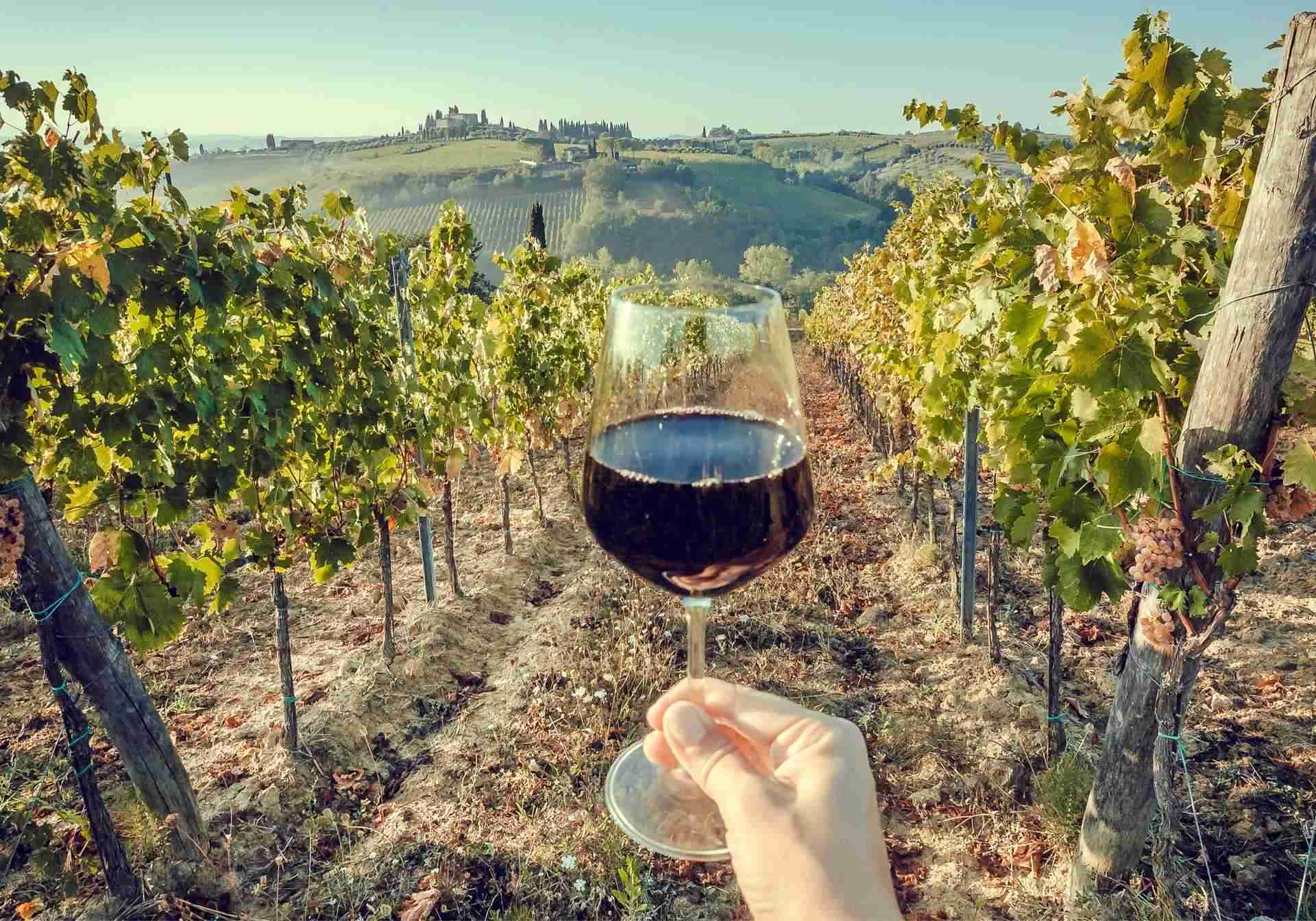
Experience Wine Tasting: Crete is home to several renowned wineries producing high-quality wines from indigenous grape varieties. With your rental car, you can embark on a wine tasting journey through the island's vineyards, sampling a diverse selection of reds, whites, and rosés. Many wineries offer guided tours and tastings, allowing you to learn about the winemaking process and the unique characteristics of Cretan wines. Indulge in Olive Oil Tasting: Olive oil is a staple of Cretan cuisine, known for its exceptional quality and health benefits. Take advantage of your rental car to visit olive oil mills and tasting rooms, where you can sample a variety of extra virgin olive oils produced using traditional methods. Learn about the olive oil production process, from harvesting and pressing to bottling, and discover the distinctive flavors and aromas of Cretan olive oil. Explore Cultural Attractions: In addition to its culinary delights, Crete is rich in history, culture, and archaeological sites. Use your rental car to visit iconic landmarks such as the Palace of Knossos, the archaeological site of Phaistos, and the Venetian fortress of Rethymno. Immerse yourself in the island's fascinating history and heritage, exploring ancient ruins, Byzantine churches, and museums showcasing artifacts dating back thousands of years. Enjoy Outdoor Activities: Crete offers a wealth of outdoor activities for nature enthusiasts and adventure seekers. With your rental car, you can easily access hiking trails, pristine beaches, and scenic viewpoints across the island. Spend a day hiking through the Samaria Gorge, snorkeling in crystal-clear waters, or simply relaxing on the sun-drenched shores of Elafonissi or Balos. Whatever your outdoor passion, Crete has something to offer for every traveler. In conclusion, renting a car opens up a world of possibilities for exploring the diverse landscapes, cultural attractions, and culinary delights of Crete. Whether you're sampling local wines, indulging in olive oil tastings, or immersing yourself in the island's rich history and natural beauty, a rental car provides the freedom and flexibility to make the most of your journey through this enchanting Greek island.

Attend Local Festivals and Events: Crete is known for its vibrant festivals and cultural events, which showcase the island's rich heritage and traditions. With your rental car, you can easily attend local celebrations, such as religious feasts, wine festivals, and music concerts. Experience the lively atmosphere, taste traditional delicacies, and immerse yourself in the rhythms of Cretan music and dance. From the colorful carnival celebrations of Rethymno to the religious processions of Easter in villages across the island, there's always something happening in Crete. Discover Natural Wonders: Crete is blessed with an abundance of natural beauty, including dramatic gorges, cascading waterfalls, and rugged coastlines. Use your rental car to explore some of the island's most breathtaking natural wonders, such as the Samaria Gorge, the Imbros Gorge, and the Preveli Palm Beach. Take a scenic drive through the White Mountains, stopping to admire panoramic views of the surrounding landscape, or hike to hidden waterfalls and secluded beaches for a truly unforgettable experience. Sample Local Delicacies: No visit to Crete is complete without indulging in the island's delicious cuisine. With your rental car, you can seek out local tavernas and eateries known for serving authentic Cretan dishes made with fresh, seasonal ingredients. Taste traditional specialties such as dakos (barley rusk salad), kalitsounia (cheese pies), and bougatsa (sweet custard pastry), paired with local wines and spirits for a true taste of Crete's culinary heritage. Experience Traditional Hospitality: One of the highlights of traveling in Crete is the warm hospitality of the locals. With your rental car, you can venture off the beaten path and discover charming villages where you'll be welcomed with open arms by friendly villagers. Experience traditional Cretan hospitality firsthand as you share a meal with locals, participate in cultural activities, and learn about age-old traditions passed down through generations. In summary, renting a car is the perfect way to enhance your experience in Crete, allowing you to explore the island's diverse landscapes, cultural attractions, and culinary delights at your own pace. Whether you're attending local festivals, discovering natural wonders, sampling local delicacies, or experiencing traditional hospitality, a rental car provides the freedom and flexibility to create lasting memories of your journey through this enchanting Greek island.

Experience the Culinary Delights of Crete: From traditional tavernas to seaside eateries, Crete offers a culinary journey like no other. With your rental car, explore the island's diverse gastronomic scene, sampling local delicacies and savoring the flavors of Cretan cuisine. Whether you're indulging in fresh seafood by the sea or tasting authentic dishes in charming mountain villages, Crete's culinary landscape is sure to tantalize your taste buds. Discover Hidden Gastronomic Gems: Venture off the beaten path and uncover hidden gastronomic treasures tucked away in small villages and rural areas. With your rental car, you can easily access local tavernas and family-owned restaurants that may not be easily reachable by public transportation. From quaint roadside eateries serving homemade specialties to rustic wineries offering wine tastings, there's always something new to discover in Crete's culinary scene. Embark on a Gastronomic Road Trip: Create your own culinary itinerary and embark on a gastronomic road trip across Crete. With your rental car as your guide, you can visit different regions of the island, sampling a diverse array of dishes along the way. Stop at local markets to taste fresh produce, visit olive oil mills for tastings, and explore traditional villages known for their culinary traditions. Whether you're enjoying a leisurely meal overlooking the sea or picnicking amidst olive groves, a gastronomic road trip in Crete promises unforgettable experiences. Immerse Yourself in Local Culture: Dining in Crete is more than just a meal—it's an opportunity to immerse yourself in the island's rich culture and heritage. Use your rental car to attend local festivals and events celebrating Cretan gastronomy, such as wine festivals and olive oil tastings. Engage with locals, learn about traditional cooking methods, and experience the warmth and hospitality of Cretan culture firsthand. By incorporating these SEO enhancements, the text becomes more optimized for search engines while still providing valuable information and engaging content for readers.